
How to Find Your Property Line Before the First Post Goes In
A string line, a bag of concrete mix, and a guess at where the yard ends: that combination works fine for a garden bed, and it can be a genuine problem for a fence. Move a flower bed two feet next spring, and nothing is lost. Move a fence post two feet onto a neighbor's side, and the mistake is sitting in cured concrete by the next morning. Unlike almost every other yard project, a fence built over the line escalates: it can become a legal dispute, and in some cases, a forced removal.
So the line has to come from somewhere better than a guess before the first hole is dug. Four sources offer to tell you where it runs, and they are not close to equal. The one that holds up is a licensed boundary survey with your corners pinned and the line between them staked, because it is the only source of the four that leaves a mark on your dirt you can build to. The recorded plat and the deed's legal description sit underneath that survey as the paper it works from, useful and incomplete on their own. What a neighbor remembers and where an old fence happened to sit carry no weight at all, and that is where boundary arguments start.
Neighbor Memory and the Old Fence Line Carry No Weight
Ask a neighbor where the property line runs, and you will get an answer. It will be the old fence, or that row of shrubs, or the gravel strip between the driveways. None of it was ever measured. A prior owner may have set a fence a few feet off the real line to dodge a tree root, a low spot, or an argument nobody remembers anymore, and every fence built since then just repeats the same guess in a new location. That is also the shape a boundary disagreement takes: two people who both believe an unmeasured feature is the line, right up until a survey says otherwise.
If a disagreement over the line has already hardened into an argument with your neighbor, that becomes a legal question for an attorney to sort out.
What a Plat or Subdivision Map Shows on Paper
A plat, the map recorded when the subdivision was laid out, gives the shape of your lot and the length of each side, in feet, measured from a fixed reference point. That is real information: it can tell you that the lot is a rectangle with a drainage easement running along the back edge, or that a side line angles slightly rather than running square to the street. What it cannot do is put those measurements on the ground. A plat was drawn once, at the county office, from survey math done at the time the subdivision was created. Reading a plat tells you the geometry of your lot. Getting that geometry onto the dirt is a separate step, and it takes someone qualified to do it.
The Deed's Legal Description Needs a Translator
Your deed carries its own description of the boundary, sometimes written as a string of compass bearings and distances (metes and bounds), sometimes as a lot-and-block reference back to the recorded plat. That description is exact: a licensed surveyor can read it and land on the same lines every time, no matter how many times it is re-measured. It is still language and numbers until someone translates it into a place to stand. "North 40 degrees east, 120 feet" means nothing to a shovel without a known starting point and a compass bearing tied to it. The deed answers what the line is, in exacting terms. Turning that into where the line falls on your lot takes a surveyor with the instruments to run a bearing from a known monument, which is beyond what a tape measure and a printed deed can reach.
A Survey Is the Only Source That Settles the Question
A licensed surveyor combines the deed's legal description with the recorded plat and field measurements taken from established reference points, then sets physical markers at your corners: iron pins or capped rebar stamped with the surveying firm's license number. That is a corner survey, and it answers where the corners sit. A full boundary survey goes one step further and stakes or flags the line running between those corners too, which is the version that gives a fence crew a line to follow across a slope, a tree, or a curve in the yard, where two pins alone leave the middle to eyeballing. Ask for the line marked, specifically, if a fence is the reason for the survey; a corner-only survey can leave the middle of a long run open to interpretation. Where a property has changed hands more than once, or the old corner markers have gone missing, a survey is the step that ends the guessing.
What an Old Iron Pin Really Tells You
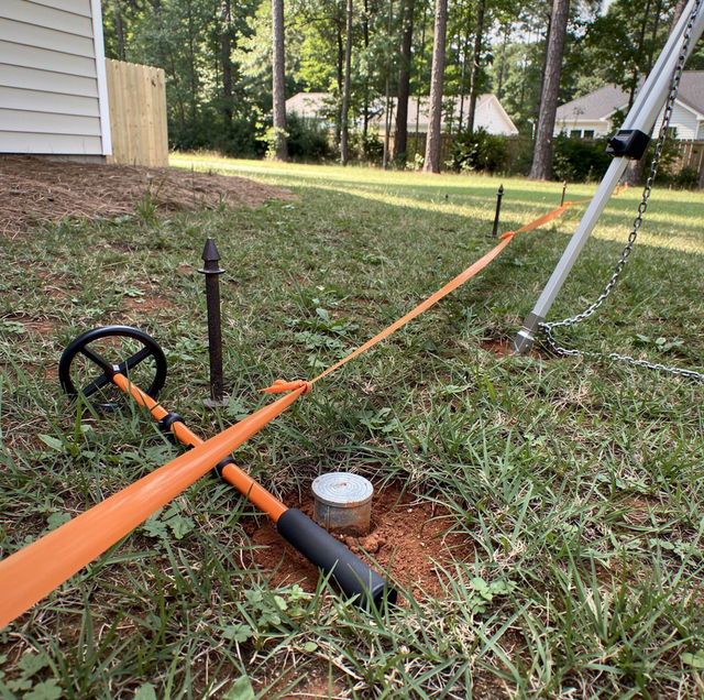
Between calling a surveyor and simply guessing sits a middle step: sweep your likely corners with a metal detector and see whether a pin turns up. Sometimes one does. Iron pins and capped rebar are the standard corner monument on a platted lot, and a detector will find one a few inches down, sometimes under years of accumulated turf. Finding one feels like finding the answer, but a pin is evidence, not proof: pins get dragged out of position by grading equipment, bent sideways by a mower deck or a truck tire, or pulled out entirely when an old fence comes down. A pin sitting exactly where the plat's measurements say a corner should be is a strong sign. A pin standing alone, with no matching marker at the next corner to confirm the line between them, or one that sits a foot or two off from where the numbers put it, is worth confirming before you set four hundred feet of fence on it.
A magnetic locator reads only ferrous metal, so it ignores aluminum siding and PVC irrigation, but rebar in a nearby slab is carbon steel and reads the same as a pin. Brass discs stay invisible to it.
What Can Still Move a Confirmed Fence Line
Squaring away utility flags, permits, and yard clearing before installers arrive is its own checklist, and it assumes the boundary below is already settled. Knowing exactly where your line runs settles one question among several. Three separate things can still restrict or redirect a fence after the line itself is no longer in doubt, and none of them show up just by finding the corners.
Easements are the first, and they catch owners who did everything else right. A utility or drainage easement is a right, held by a utility company or the county, to reach or run lines through part of your lot, and its edge can fall ten or more feet inside your boundary. You can be standing squarely on your own property and still be digging across a corridor someone else has a standing right to use. Recorded easements are shown on a plat or a survey, and the recorder's office or the surveyor doing your work can confirm what is on record before a hole is opened. An easement also does not disappear under a fence built across it: the holder can come back to trench or dig, and whatever stands in the way comes out.
Setbacks work from the same boundary you just paid to confirm. Many jurisdictions keep a strip along the line clear of construction, which makes the setback a separate rule from the boundary question, so a fence set precisely on a confirmed line can still sit inside that strip. How wide it runs, whether it changes for a corner lot, and whether a taller privacy fence gets a different number than a shorter one are questions for your local building or planning department, answered for your specific parcel.
Your neighbor is the third, and the one a survey cannot settle. When a fence will sit on a confirmed boundary between two properties, the useful step is getting that neighbor's agreement in writing before anything is dug, covering who pays for what, which side faces which yard, and who handles upkeep later. A confirmed line settles where the fence can go and says nothing about how the person on the other side feels about what goes up on it. Paper signed before the concrete cures is what keeps that from surfacing afterward.
None of the three is work a fence contractor can do for you. A fence contractor cannot tell you where your property line runs; locating a boundary is survey work, and a fence crew carries neither the instruments nor the standing for it. A contractor who guesses at a line to spare you a survey is taking on a risk that lands back on you regardless. What a licensed, insured contractor can do is build to whatever line you identify, whether that is a staked survey, confirmed corner pins, or a written agreement with your neighbor, and ask about recorded easements and setback rules before quoting the job, since either one can change what is allowed to go where you want a fence.
Frequently Asked Questions
Your deed is recorded at the county register of deeds or recorder's office, and that index can be searched by owner name, address, or parcel number; many offices now publish it online, so a copy can be pulled without a trip to the counter. The description you want sits in the body of the deed itself, right after the property address, though older instruments sometimes carry it on an attached exhibit instead. If the recorded copy is faint or hard to read, ask whether a scanned image of the original page is held alongside the typed index entry.
Not reliably. A tax assessor's map is drawn for valuation and to divide an area into parcels for billing, and it carries a printed disclaimer stating that it is not intended for boundary or survey use. The parcel lines on them are generalized and can sit slightly offset from the recorded plat, which is exactly the gap that puts a fence a few feet off from where you meant it to go.
Not the same document. A mortgage or title company survey is a simplified location sketch confirming the house sits within the lot and clear of a setback, and it is not the product that puts markers in the ground. It exists to satisfy a lender, so treat it as a starting point and confirm the line separately before you build to it.
A straight boundary is described with a bearing and a distance, like the metes-and-bounds example above, but a curved line, common along a cul-de-sac or a road frontage, needs additional data: a radius, an arc length, and a chord bearing that together define the curve's exact path. Surveyors and title companies both work from this same curve data, which is why a lot on a curve still gets platted and surveyed with the same precision as a square one.
Survey work is scheduled ahead, so make the call early, before a fence date is on the calendar. Field time on site is short by comparison, a few hours to most of a day, and it stretches with the lot's size, the number of corners, and how much vegetation has to be cleared to reach them. The drawing that comes afterward is a separate office step, and that turnaround can add days to the field visit, so ask for both timelines when you book.
That is a boundary dispute, and it belongs with an attorney. One route an attorney may raise is a written boundary line agreement, signed and recorded by both owners, which fixes the line going forward without a court case; whether it fits a given situation is a question only an attorney can answer.
A free on-site consultation walks your line with you and raises the easement and setback questions before a quote — no obligation. AR Fence serves Fayetteville, Hope Mills, and Raeford. Call (910) 994-3634.
